
1.1.1.2. Atlas: Discovering Linked Places
Beta: live now, for invited testers
Atlas is the new map-first way of exploring the World Historical Gazetteer. It is live at whgazetteer.org/atlas/ and is open to WHG staff and signed-in beta testers only. It is changing as testers’ reports come in. This page belongs to the draft v4 user guide; to help test it, follow checklist N of the Beta Testing Plan.
1.1.1.2.1. The problem Atlas solves
The same real-world place is described, over and over, by many different sources. GeoNames, Wikidata, OpenStreetMap, the Getty Thesaurus, historical gazetteers, and data contributed by researchers all record their own version of it — each with its own spellings, coordinates, dates, and categories.
WHG brings roughly 47 million of these records together in one place. That is wonderful for coverage, but it means that a single city can show up dozens of times. Search for Istanbul and you might find separate records for Byzantion, Constantinople, Constantinopolis, Tsargrad, Qusṭanṭīniyya, and İstanbul — all the same place on the ground, scattered across sources and centuries.
Atlas’s job is to recognise that these belong together, and to show you one place, many sources, instead of a pile of look-alikes.
1.1.1.2.2. What Atlas does
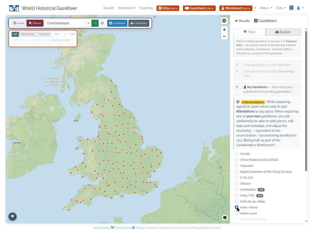
Fig. 1.1 Atlas is map-first: explore the index on the map — here browsing a single source gazetteer, Index Villaris (1680), across Britain — then open any place to see its sources.
As you explore the map, Atlas groups records that refer to the same place and presents each group as a single result you can open up to see all its sources. Nothing is decided in advance and frozen — the grouping is worked out on the spot, live, from the records your search actually returns.
Think of it like a librarian who, faced with a stack of index cards written by different people in different languages, quietly sorts them into piles — one pile per real place — while you watch.
1.1.1.2.3. How Atlas decides two records are the same place
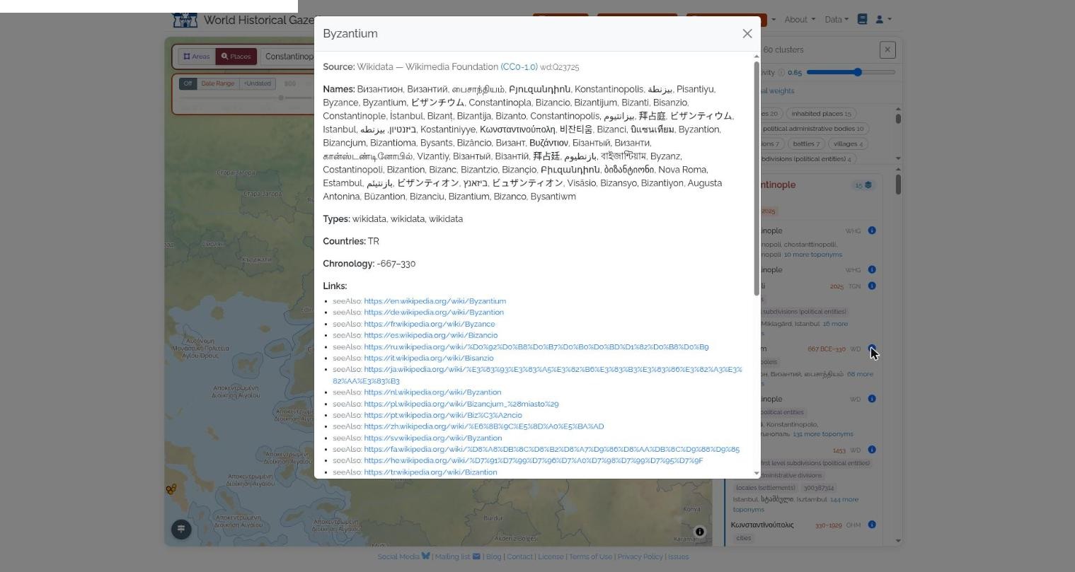
Fig. 1.2 One source record opened in full: Byzantion, under dozens of names across scripts and centuries (Constantinople, Qusṭanṭīniyya, Tsargrad, İstanbul…). Atlas compares the sound of such names — not just their letters — when it weighs the evidence.
Atlas never relies on a single clue. Like a good detective, it weighs up several kinds of evidence and asks how strongly, taken together, they suggest that two records describe the same place:
Name — do the names sound alike, even across different alphabets and languages? Atlas compares the sound of names, not just their letters, so it can tell that Köln and Cologne, or القاهرة and Cairo, are close relatives. (This is powered by WHG’s phonetic matching.)
Location — are the two records in the same spot on the map?
Time — do their date-ranges overlap? A record for a Roman fort and a modern town in the same place may be different things worth keeping apart.
Kind of place — are they the same type of thing — a city, a river, a temple? — judged using the Getty Art & Architecture Thesaurus, a standard hierarchy of place types.
Stated links — has anyone explicitly said “these two are the same” (or “these are not the same”)? Authorities like the Library of Congress and Wikidata publish such links, and WHG contributors can add their own.
Each clue produces a score, and the scores are combined into a single measure of how likely it is that two records are the same place.
1.1.1.2.4. You are in control: the grouping dial
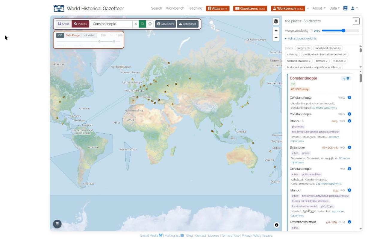
Fig. 1.3 A toponym search for Constantinople: matching records are grouped into results (each openable to all its sources), while the Merge sensitivity dial and signal-weight controls re-group the map instantly.
Different questions call for different strictness. A quick overview might want places grouped generously; careful scholarship might want only near-certain matches grouped.
So Atlas gives you a dial (a slider, labelled Merge sensitivity). Grouping is a view of the results, not a change to the data: records are never merged, and each keeps its own sources. Slide towards loose and more records are grouped together; slide towards strict and only the most confident matches are grouped. You can even adjust how much each kind of evidence counts — for instance, leaning more on names and less on exact location when you are working with sparsely-located historical data. Every adjustment re-groups the map instantly.
1.1.1.2.5. It all happens in your browser
The grouping is computed on your own device, in the browser, in a fraction of a second. That is what makes the live dial feel instant — there is no round-trip to a server each time you nudge it.
It also has an important privacy benefit. In the companion Collaborative Workbench, you can bring your own place data and see how it lines up with WHG. Because the matching runs in your browser, your unpublished data never has to leave your computer to be compared against the gazetteer.
1.1.1.2.6. Confirmed links and your corrections
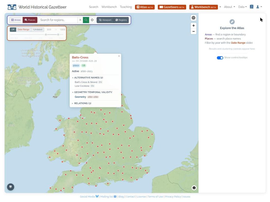
Fig. 1.4 Opening a place on the map shows its record — names, active dates, temporal validity, and stated relations — the raw material behind confirmed links and contributor corrections.
Some links are more than a good guess. When an authority or a WHG contributor states outright that two records are the same place — or deliberately that they are not — Atlas treats that as a firm instruction rather than a clue to be weighed. These confirmed links always come from WHG’s servers, so they reflect the community’s accumulated knowledge.
Today Atlas uses the confirmed links that authorities and WHG already hold. Tools for contributors to assert that two records are the same place, or are distinct, are still to come (see What’s coming).
1.1.1.2.7. Why not just fix the groups once and for all?
Older versions of WHG did exactly that: places were grouped a single way, in advance, and that was that. But historical places are genuinely contested — experts disagree about whether two names refer to one place or two, and the right answer often depends on the period and the research question. A single frozen answer cannot serve everyone.
Atlas embraces that. Instead of one fixed set of groups, it gives you a transparent, adjustable view you can tune to your own needs — and it improves continuously as authorities publish new links and contributors share their expertise.
1.1.1.2.8. Searching
The search bar has an Areas / Places toggle.
Places searches place names. A menu beside the box sets the match: Exactly, Starts with, Contains (the default) or Sounds like. Sounds like finds spelling variants across scripts. With an area selected, a Places search is limited to that area.
Areas looks up a region or country by name. Choosing a suggestion selects the area: it appears as a chip under the bar and is outlined on the map. Several areas can be selected together. You can also click a region on the map.
Name search over areas works for OpenStreetMap and OpenHistoricalMap boundaries. For PeriodO, Cliopatria, Native Land and OSM (miscellaneous) regions, the search box says “Name search isn’t available for this source yet (planned)” and names the source, rather than showing no results. Pick those regions on the map instead.
A Wikidata record whose own label is missing is shown under its preferred place name, not as a bare identifier such as “Q12345”.
When a search leaves a source out unless you ask for it by name (today, GB1900, namespace gb), a
small note under the results reads “Some sources are excluded by default” and lists it.
1.1.1.2.9. When something goes wrong
Atlas says which of three things happened, so you can tell a slow search from an outage from a missing permission.
Message |
Meaning |
|---|---|
“… took too long to come back. The service is running; please try again.” |
The search service is up but slow for this request. Try again, or narrow the search. |
“… is temporarily unavailable; the search service did not answer.” |
The service could not be reached, and a banner at the bottom of the screen says so. This is a failure to ask, not a finding that nothing matches. |
“This is a beta feature; request access to use it.” |
Your account does not have beta access. The link opens the contact dialog. |
“Not found” is reserved for the case where the service answered and has no such place. Failures that used to appear only in the browser console are now shown as a brief message as well.
1.1.1.2.10. Source and licence, on every result
Each cluster card ends with a Source & licence footer: one entry per source among its members, each with that source’s licence badge.
Records from contributed datasets read “licence per dataset (see Details)”, because each contributed dataset has its own licence, shown on the record itself.
Some sources are indexed and searchable, but their licence does not allow WHG to redistribute their records (for example China Historical GIS, Native Land and
kain_par). Their entries read “details withheld (licence)”. The place still appears on the map and in results, but Details opens an explanation instead of the record: whose data it is, and a link to the source, where you can obtain it under the source’s own terms. This is deliberate and is not an error.
1.1.1.2.11. Selecting an area
When you select a region (by name or by clicking it), Atlas uses the region’s exact outline where one is available, so a region larger than the screen is selected whole and searches are limited to its true shape. If the exact outline cannot be fetched, Atlas falls back to the outline drawn in the map tiles, which is a simplified version of the same boundary and can be incomplete for regions bigger than the current view.
Exact outlines are not fetched for sources whose licence does not allow WHG to redistribute their records, or for contributed datasets whose licence and visibility are not yet checked. For these, the map’s own outline is used for display.
1.1.1.2.12. Controls marked “planned”
Some controls are visible but disabled and carry a planned tag: Itinerary, Network and Attest in the Gazetteers panel. They show where Atlas is heading and do nothing yet. Comments on how they should work are welcome.
Some gazetteers (OpenStreetMap and OpenHistoricalMap) cannot be browsed as a whole in Explore mode.
A link such as ?gazetteer=osm selects such a gazetteer as a search filter instead and says so in a
notice.
1.1.1.2.13. Reporting a problem
Choose BETA menu, then Report a snag, or use the snag link in the Atlas navigation. The Atlas link
opens the form with the feature area Atlas already chosen, and the report carries the Atlas state
(in the page address it records). Say which search term and gazetteer were involved. Please do not
include content from the kain_par or vob_* gazetteers in screenshots or public reports.
1.1.1.2.14. On a phone or tablet
At 768 px wide or narrower, Atlas uses a mobile layout: the time slider, the signal-weight sliders, the basemap menu and the overlay panels are laid out for touch, and panels open without permanently covering the search box. The guided tour is not offered at this width. On a phone the share button opens the device’s share sheet.
1.1.1.2.15. What’s coming
Contributor tools to confirm or reject links, shared with the Collaborative Workbench.
The controls marked planned: Itinerary, Network and Attest.
Name search for the region sources that do not have it yet.