
2. Application Programming Interfaces (APIs)
⚠️ Tokens are required for access to most WHG API endpoints (see below).
Full, interactive API documentation is available at https://whgazetteer.org/api/schema/swagger-ui/
The World Historical Gazetteer (WHG) provides two complementary APIs:
2.1. Entity API
Access canonical representations of our entities: Places, Datasets, Collections, Areas, and PeriodO Periods.
Retrieve full metadata, names, types, geometries, temporal bounds, authority info, and linked resources.
Machine-readable feature endpoints return valid Linked Places Format (LPF) v1.1 for GIS and reconciliation tools.
2.1.1. Entity Endpoints
Endpoint |
Method |
Description |
|---|---|---|
|
GET |
Human-readable detail page (redirects to web app) |
|
GET |
Machine-readable LPF feature (JSON) |
|
GET |
HTML preview snippet |
Valid entity types: place, dataset, collection, area, period.
2.1.2. Place Identifiers and Source Namespaces
Place identifiers include a namespace prefix that indicates the originating source. For example:
place:169687— a WHG place (no prefix, or equivalentlywhg)place:gn:745044— a GeoNames placeplace:tgn:7010731— a Getty TGN place
All places are returned in Linked Places Format (LPF) v1.1 from the /api endpoint, regardless of source, with a standard structure including @context, type: "Feature", @id, geometry, names, types, links, and when.
You can use the namespaces parameter on Reconciliation and Suggest endpoints to restrict which sources are searched (see Source Namespaces).
Example: Fetching a GeoNames place
curl "https://whgazetteer.org/entity/place:gn:745044/api?token=<token>"
{
  "@context": "https://raw.githubusercontent.com/LinkedPasts/linked-places/master/linkedplaces-context-v1.1.jsonld",
  "type": "Feature",
  "@id": "https://whgazetteer.org/entity/place:gn:745044/api",
  "properties": {
    "title": "İstanbul",
    "ccodes": ["TR"],
    "source_id": "gn:745044"
  },
  "geometry": {
    "type": "Point",
    "coordinates": [28.94966, 41.01384]
  },
  "names": [
    {"toponym": "Constantinople", "lang": "en"},
    {"toponym": "Byzantium", "lang": "en"},
    {"toponym": "İstanbul", "lang": "tr"}
  ],
  "types": [{"identifier": "PPLA", "label": "P", "sourceLabel": "P.PPLA"}],
  "links": [],
  "when": {}
}
Example: Fetching a WHG place
curl "https://whgazetteer.org/entity/place:169687/api?token=<token>"
{
  "@context": "https://raw.githubusercontent.com/LinkedPasts/linked-places/master/linkedplaces-context-v1.1.jsonld",
  "type": "Feature",
  "@id": "https://whgazetteer.org/entity/place:169687/api",
  "properties": {
    "title": "London",
    "ccodes": ["GB"],
    "fclasses": ["P"],
    "dataset": "Getty TGN (partial)",
    "src_id": "7011781"
  },
  "geometry": {"type": "Point", "coordinates": [-0.1275, 51.50722]},
  "names": [{"toponym": "London", "citations": [{"id": "...", "label": "Getty TGN"}]}],
  "types": [{"label": "inhabited places", "identifier": "aat:300008347"}],
  "links": [{"type": "closeMatch", "identifier": "tgn:7011781"}],
  "when": {"timespans": [{"start": {"earliest": "43"}, "end": {"latest": ""}}]}
}
2.1.3. Persistent Identifiers (w3id.org)
WHG entities now have permanent identifiers under the https://w3id.org/whg/ namespace. These identifiers resolve via
HTTP 303 redirects to the WHG Entity API and are intended to be stable, citable URIs.
Canonical identifier pattern
Base:
https://w3id.org/whg/Entity:
https://w3id.org/whg/id/{id}→https://whgazetteer.org/entity/{id}/api(303 redirect)
Content negotiation for the base namespace
If
Accept: application/jsonorapplication/ld+json, redirect (303) tohttps://whgazetteer.org/api/schema/.If
Accept: text/htmlorapplication/xhtml+xml, redirect (303) tohttps://whgazetteer.org/.Otherwise, return HTTP 404.
Examples by entity type
Place (WHG):
https://w3id.org/whg/id/place:169687Place (GeoNames):
https://w3id.org/whg/id/place:gn:745044Dataset:
https://w3id.org/whg/id/dataset:1234Collection:
https://w3id.org/whg/id/collection:5678Area:
https://w3id.org/whg/id/area:9012PeriodO period:
https://w3id.org/whg/id/period:3456
Note on DOIs for Published Datasets and Collections
Upon publication, Datasets and Collections are also assigned DOIs. WHG DOIs use the prefix
10.83427and follow a hyphenated pattern (for example,10.60681/whg-dataset-1234), which differs from the colon-separated w3id.org identifiers. WHG DOIs are provided through DataCite with support from the University of Pittsburgh Library System.
2.1.4. Namespace Prefix (prefix.cc)
The whg: namespace prefix is registered at http://prefix.cc/whg and expands to
https://w3id.org/whg/id/. This is useful for compact identifiers in JSON-LD and JSON Schema contexts.
Example usage in a JSON Schema with JSON-LD context
{
  "$schema": "https://json-schema.org/draft/2020-12/schema",
  "$id": "https://w3id.org/whg/schema/place.json",
  "@context": {
    "whg": "https://w3id.org/whg/id/"
  },
  "title": "WHG Place Reference",
  "type": "object",
  "properties": {
    "id": {
      "type": "string",
      "format": "iri",
      "examples": ["whg:place:169687"]
    }
  },
  "required": ["id"]
}
2.2. Reconciliation Service API
Compatible with OpenRefine and implements the Reconciliation Service API v0.2.
Supports both Place and PeriodO Period suggestions, batch reconciliation, and property enrichment.
Searches across multiple source indices simultaneously (WHG, GeoNames, Getty TGN, and others).
Results can be filtered by source namespace, country code, GeoNames feature class, and AAT place type.
Data Extension is supported, allowing users to enrich their tables with properties like Geometry, Alternative Names, Temporal Range, and Country Codes after reconciliation.
2.2.1. Reconciliation Endpoints
Endpoint |
Method |
Description |
|---|---|---|
|
GET |
Service metadata manifest |
|
POST |
Batch reconciliation queries or data extension |
|
GET |
Discover extensible properties |
|
GET |
Typeahead entity suggestions by prefix |
|
GET |
Typeahead property suggestions by prefix |
2.2.2. Query Parameters
The following parameters can be included in each query object within a reconciliation request, or as query-string parameters for the suggest endpoint.
2.2.2.1. Text Search
Parameter |
Type |
Description |
|---|---|---|
|
string |
Free-text search string. Required unless a spatial filter ( |
|
string |
Search mode: |
2.2.2.2. Facet Filtering
Parameter |
Type |
Reconcile |
Suggest |
Description |
|---|---|---|---|---|
|
array or string |
✅ |
✅ |
ISO 3166-1 alpha-2 country codes. Format: |
|
array or string |
✅ |
✅ |
GeoNames feature classes: |
|
array or string |
✅ |
✅ |
AAT place type identifiers (e.g. |
|
string |
✅ |
✅ |
Comma-separated source namespace codes. |
2.2.2.3. Temporal Filtering
Parameter |
Type |
Description |
|---|---|---|
|
integer |
Start year for temporal filtering. |
|
integer |
End year (default: current year). Must be ≥ |
|
boolean |
Include results with no temporal metadata (default: true). |
2.2.2.4. Spatial Filtering
Parameter |
Type |
Description |
|---|---|---|
|
object |
GeoJSON geometry for spatial restriction (see formats below). |
|
array or string |
Restrict to places spatially inside the region formed by the union of one or more existing places’ geometries, given by namespaced place IDs. Format: |
|
string |
How |
|
string |
Spatial relation for |
|
float |
Circular search: latitude (-90–90), longitude (-180–180), radius in km. All three required together. |
|
array |
IDs of user-defined stored areas. |
The bounds parameter accepts two formats:
Plain GeoJSON geometry (preferred):
{"type": "Polygon", "coordinates": [[[...]]]}— anyPolygonorMultiPolygongeometry.GeometryCollection wrapper:
{"geometries": [{"type": "Polygon", "coordinates": [[[...]]]}]}— legacy format, still supported for backward compatibility.
Filtering by place ID (contained_in) is the most convenient way to scope results to a region you can already name — a country (un:ita), an administrative area (osm:r365331), or any other place with a polygon. For example, {"contained_in": ["un:ita"], "containment": "exact", "relation": "within"} (no query) returns the places whose geometry lies entirely within Italy. With relation: "intersects" (the default) a feature need only overlap the region, so large/historical polygons that straddle the border are included.
2.2.2.5. Other
Parameter |
Type |
Description |
|---|---|---|
|
integer |
Restrict to a specific dataset ID. |
|
boolean |
Include results with no spatial metadata (default: true). |
|
integer |
Maximum results per query (default: 100, max: 1000). This is the standard Reconciliation API v0.2 parameter name. |
2.2.3. Source Namespaces
WHG searches across multiple place indices. Each source is identified by a namespace prefix:
Namespace |
Source |
ID Example |
|---|---|---|
|
WHG places |
|
|
GeoNames |
|
|
Getty TGN |
|
|
Wikidata |
|
|
OpenStreetMap |
|
|
OpenHistoricalMap |
|
|
Pleiades |
|
Note: The
gbnamespace (Ordnance Survey) is excluded from results by default to reduce noise. To include it, pass an emptyexclude_namespaceslist via the gateway API.
When namespaces is omitted, all available sources are searched (except those in the default exclusion list). When specified, only the listed sources are queried — this can improve performance and relevance.
Examples:
"namespaces": "whg"— search only WHG places"namespaces": "gn,tgn"— search GeoNames and Getty TGN"namespaces": "whg,gn"— search WHG and GeoNames
2.2.4. Result Format
Each entry in a query’s result array is an object with the following fields:
Field |
Type |
Description |
|---|---|---|
|
string |
Entity ID (e.g. |
|
string |
Canonical name of the matched entity. |
|
number |
Match score on a 0–100 scale (note: not the 0–1 range some Reconciliation API examples imply). |
|
boolean |
|
|
string |
Short human-readable summary, typically of the form |
|
array |
Variant toponyms in any language. |
|
array |
LPF type objects. |
2.2.5. Filter Behaviour and Common Pitfalls
Because WHG aggregates several upstream sources (GeoNames, Wikidata, OSM/OHM, Getty TGN, Pleiades, contributor datasets) that differ in how completely they populate metadata, three of the filters can be unexpectedly aggressive. Understanding when each one bites makes reconciliation results far more useful, especially for historical-place workflows.
fclassesis sparsely populated upstream. Many ingested records — OSM relations, Wikidata items, contributor datasets — carry no GeoNames feature class at all. Applyingfclasses=["P"]orfclasses=["A"]will exclude them entirely, even when the named entity is clearly a populated place or admin area. Empirical example:query="Sardinia", fclasses=["A"]returns 0 results; the same query withoutfclassesreturns three valid matches. For exploratory reconciliation, prefer omittingfclassesand disambiguating bycountriesor post-hoc result ranking.startandendare hard filters;undated=trueis not a window-widener. Theundated=trueflag only includes records that carry no temporal metadata. Records that do carry dates (which is the case for nearly every modern GeoNames or OSM ingestion) are still hard-excluded when those dates sit outside[start, end]. The practical consequence: probing a medieval-only window can silently drop the majority of valid hits. Empirical example:query="Portofino", start=1350, end=1500, undated=true, countries=["IT"]returns 0 results; the same query withoutstart/endreturns three valid matches. For reconciling historical names against the modern index, consider treating temporal context as a post-hoc disambiguator rather than a pre-filter.countriestrusts upstream country metadata, which is occasionally wrong or missing. WHG forwards each source’s country tagging without correction, so a legitimate hit can be filtered out when the upstream record is mis-attributed. Empirical example: Île Sainte-Marguerite (off Cannes, France) is taggedCountry: ITin one upstream source and is excluded bycountries=["FR"]. A robust pattern is to query first with the country filter, and if the result list is empty, retry without it and post-filter on the result’s owndescriptionfield — which is itself derived from the source’s country tag, so this acts as a self-consistency check rather than a hard veto.
2.2.6. Geometry Recovery When the Top Hit Has No Centroid
WHG indexes both source records (place:gn:…, place:osm:…, place:wd:…, place:tgn:…) and WHG-native abstract entities (place:NNN, no namespace prefix) that aggregate them. The native entity is what match: true usually returns, but it does not always carry its own geometry — whg:geometry_centroid may come back as an empty array even when the named place clearly has a well-known location.
When this happens, the recommended pattern is to walk through the other results in the same reconciliation response (they typically reference the same physical place via different upstream sources) and request whg:geometry_centroid for each until you find one populated. A typical reconciliation of query="Portofino" returns five candidate IDs from gn, osm, and tgn namespaces; if the top WHG-native ID has no centroid, the GeoNames or OSM siblings usually do.
2.2.7. Data Extension Properties
After reconciliation, you can enrich your data with these properties via the extend endpoint:
Place properties:
Property ID |
Description |
|---|---|
|
Preferred/canonical place name |
|
List of all toponyms |
|
Names as structured objects |
|
ISO country codes |
|
Country objects with code and label |
|
GeoNames feature class codes |
|
Feature class objects with label and reference |
|
AAT type objects |
|
Centroid as “lat, lng” string |
|
Full GeoJSON geometry |
|
Geometry as WKT string |
|
Bounding box |
|
Temporal data as structured objects |
|
Temporal range as year values |
|
Source dataset name |
|
WHG entity URI |
|
Entity ID and label as object |
|
Complete LPF feature |
Period properties:
Property ID |
Description |
|---|---|
|
Canonical period label |
|
Variant labels as objects |
|
Variant labels as strings |
|
PeriodO identifier |
|
Authority information |
|
Temporal bounds as objects |
|
Temporal bounds as years |
|
Spatial coverage geometry |
|
Spatial coverage objects |
2.2.8. Using the WHG Reconciliation API in OpenRefine
The WHG Reconciliation Service allows you to match place names in your spreadsheet data against WHG’s comprehensive collection of historical places. This is particularly useful for disambiguating place names and enriching your data with standardised identifiers, coordinates, and temporal information.
2.2.8.1. Prerequisites
Install OpenRefine (version 3.0 or later recommended)
Have a dataset with place name columns that you want to reconcile
Obtain your WHG API token from your Profile page at whgazetteer.org
2.2.8.2. Step 1: Adding the WHG Reconciliation Service
Open your project in OpenRefine
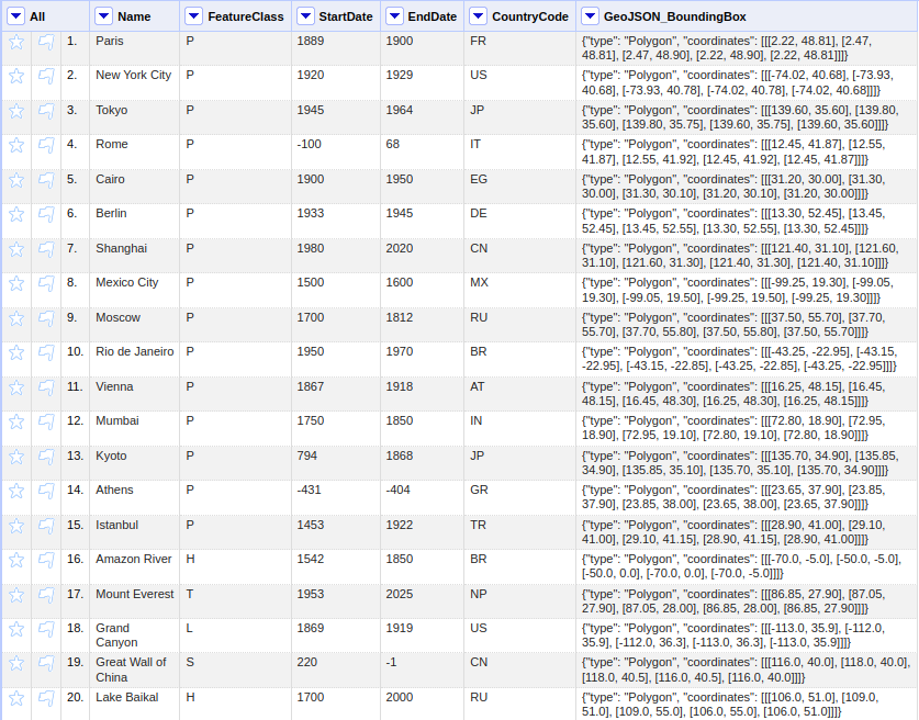
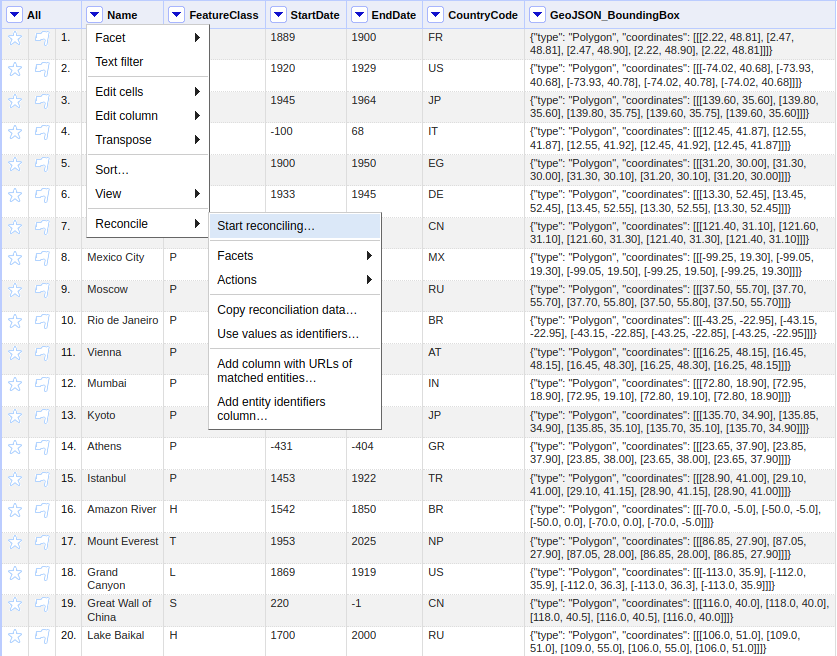
Click on the selector button in the column header containing place names, and select Reconcile → Start reconciling…
In the reconciliation dialog, click Add Standard Service (bottom left)
Enter your personalized reconciliation service URL from your WHG Profile page (see below)

Click Add Service
The WHG reconciliation service should now appear in the list of available services.
2.2.8.3. Step 2: Configuring Reconciliation Parameters
After selecting the WHG service, you can configure various parameters to improve matching accuracy:
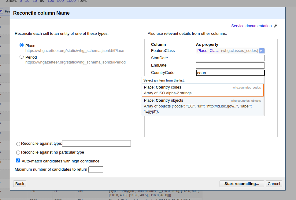
Reconcile each cell to: Select “Place” (the default entity type)
Optional: Also use relevant details from other columns: Check boxes for any columns containing additional context (e.g., country names, dates, coordinates)
2.2.8.4. Step 3: Running Reconciliation
Click Start Reconciling
OpenRefine will send your place names to the WHG API in batches
Results will appear in your column with confidence scores
Results may include places from multiple sources (WHG, GeoNames, TGN) — the source namespace is encoded in the entity ID
2.2.8.5. Step 4: Reviewing and Confirming Matches
Click on cells showing multiple candidates
Review the suggested matches in the popup dialog
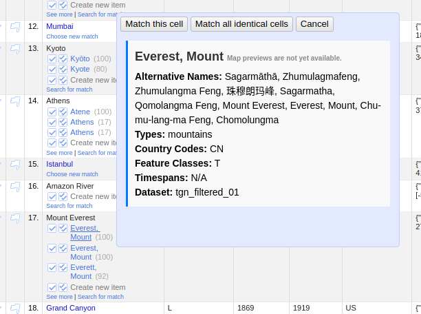
Select the correct match or choose “Create new item” if none match
Use Reconcile → Actions → Match each cell to its best candidate for bulk acceptance (use carefully!)
2.2.8.6. Step 5: Data Extension (Enrichment)
After reconciliation, you can add properties from WHG to your dataset:
Click the reconciled column header
Select Edit column → Add columns from reconciled values…
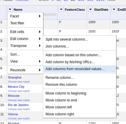
Choose properties to add (see Data Extension Properties for the full list)
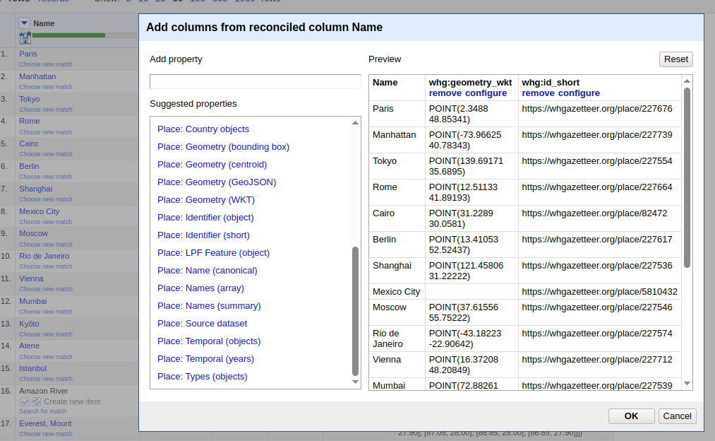
Click OK to add the new columns
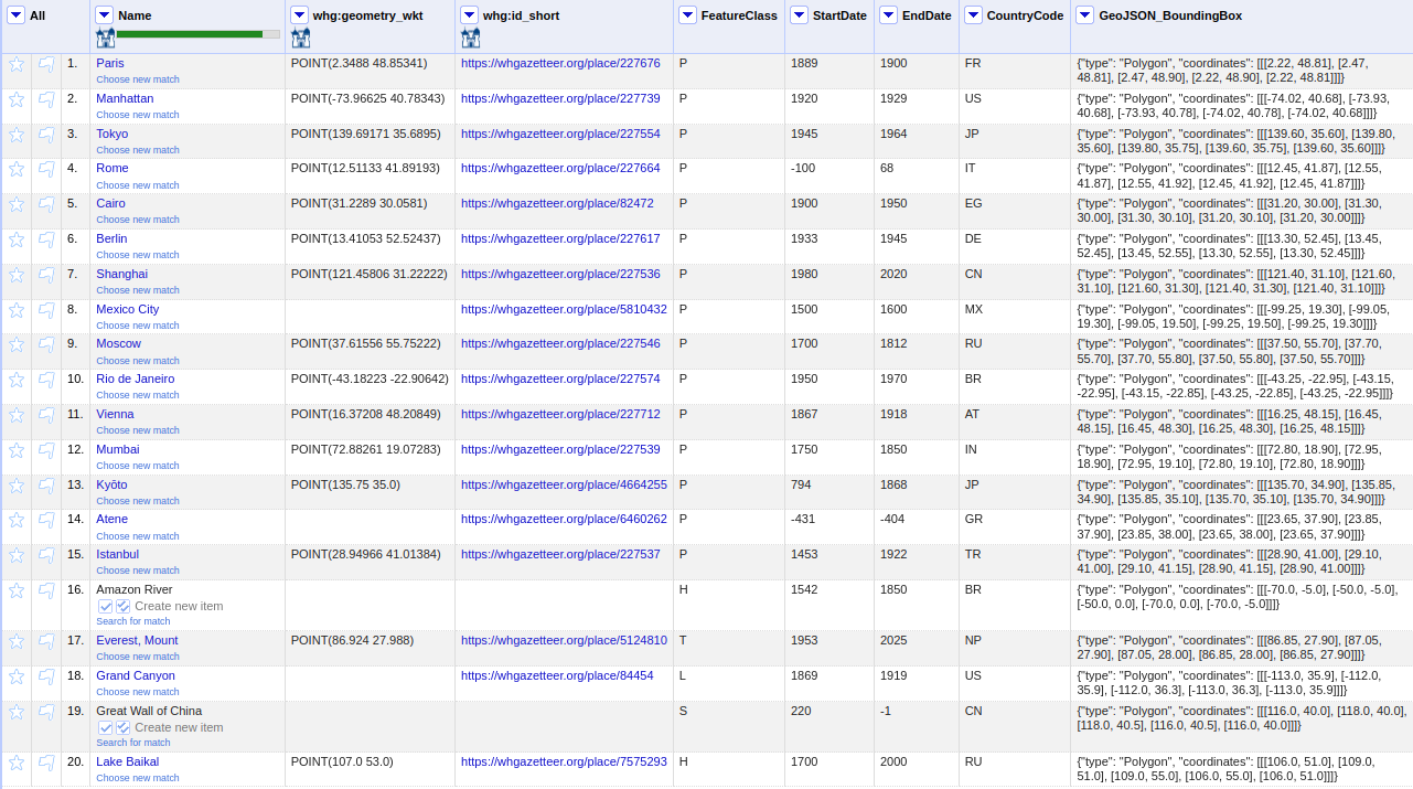
Note: Data extension works for places from all sources. For some sources, certain properties (e.g.
whg:geometry_wkt,whg:temporal_objects) may return empty values if the source data does not include them.
2.2.8.7. Tips for Better Results
Pre-process your data: Clean up obvious typos and normalise formatting
Use temporal filters: Historical place names are often ambiguous without temporal context
Leverage additional columns: Include date ranges, broader geographic context, or place types in separate columns and reference them during reconciliation
Filter by namespace: If you know your places are in a specific source (e.g. GeoNames), use
namespacesto restrict the search for faster, more relevant resultsFilter by country: Use
countriesto narrow results for common place names. Note thatfclassesis unevenly populated across upstream sources andstart/endwill hard-exclude any record with a modern date — see Filter Behaviour and Common Pitfalls.Start with a sample: Test reconciliation on a small subset before processing large datasets
Review auto-matches: Even high-confidence matches should be spot-checked, especially for common place names
2.2.8.8. Batch Reconciliation via API
For programmatic access or very large datasets, you can use the WHG Reconciliation API directly. See the full API documentation for details on query structure and response formats.
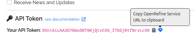
2.3. API Tokens
Registered users can generate an API token from their Profile page. Alongside the token, the Profile page also provides a preconfigured OpenRefine reconciliation service URL, which can be copied and pasted into OpenRefine’s reconciliation dialog, under “Add Standard Service”.
2.3.1. Using an API Token
The simplest way to use an API token is to include it as a query parameter in the request URL. For example:
https://whgazetteer.org/reconcile?token=<token>
Otherwise, it may be included in the Authorization header, using the Bearer schema. Requests must also include a
suitable
User-Agent to avoid bot-filters. For example:
curl -X POST https://whgazetteer.org/reconcile \
  -H "Content-Type: application/json" \
  -H "Authorization: Bearer <token>" \
  -H "User-Agent: notbot" \
  -d '{
    "queries": {
      "q1": {
        "query": "London",
        "mode": "fuzzy",
        "fclasses": ["A","P"],
        "start": 1200,
        "end": 2050,
        "undated": true,
        "countries": ["GB","US"],
        "namespaces": "whg",
        "bounds": {
          "type": "Polygon",
          "coordinates": [[
            [-1.0,51.0],
            [-1.0,52.0],
            [0.5,52.0],
            [0.5,51.0],
            [-1.0,51.0]
          ]]
        },
        "limit": 5
      }
    }
  }'
2.3.2. Suggest Endpoint Example
curl "https://whgazetteer.org/suggest/entity?prefix=Edin&limit=5&countries=GB&fclasses=P&namespaces=whg&token=<token>"
2.3.3. Entity API Example
# Fetch a GeoNames place as LPF
curl "https://whgazetteer.org/entity/place:gn:745044/api?token=<token>"

# Fetch a WHG place as LPF
curl "https://whgazetteer.org/entity/place:169687/api?token=<token>"

# Preview HTML snippet for a place
curl "https://whgazetteer.org/entity/place:gn:745044/preview?token=<token>"