
1.1.1.4. Collaborative Collections
Coming soon — preview feature
The Collaborative Workbench doc-types described here are not yet generally available. They are in beta behind the beta menu tab, open to WHG staff and invited beta testers, and are documented in advance so the design can be reviewed and refined before release. Screens, labels, and behaviour may still change. When the feature is released this notice will be removed.
1.1.1.4.1. What it is
The Workbench you already met in Map your Data is not only for reconciling a spreadsheet of places. It is one tool with many document types, sharing the same local-first, collaborative editor — the same page shell, the same “nothing leaves your browser until you choose to publish”, and the same team sharing. Reconciling a table of places (Map your Data) is simply the first doc-type; the others let you build and publish:
Place Collection — a curated set of places with notes, relations, and a narrative, for teaching, storytelling, or thematic research.
Itinerary — a journey through places in order, each stop with its own dates, with a route-line preview (see Routes, Itineraries and Networks).
Gazetteer Group — an aggregation of published gazetteers, grouped for comparison or analysis. (“Gazetteer” is the new name for what was called a “Dataset”; a “Gazetteer Group” was a “Dataset Collection” — see A note on names.)
Two further doc-types — Routes and Networks — are signposted in the tool as “Coming with v4”. They are first-class historical entities in their own right (a route or a network is more than a list of places), and arrive with WHG’s next-generation data model.
1.1.1.4.2. Starting a new document
Open the Workbench and choose New…. You are offered a tile for each doc-type:
Tile |
What you get |
|---|---|
Place Collection |
Curate a set of WHG places with notes and relations |
Itinerary |
An ordered Place Collection (a journey) |
Gazetteer Group |
Group published gazetteers together |
Map your Data |
The reconciliation workflow for a table of places |
Route / Network (disabled) |
Coming with v4 |
Published items you have permission to edit also carry an Edit in Workbench button on their own page (see Editing something already published).
1.1.1.4.3. Finding your material — “Edit published…”
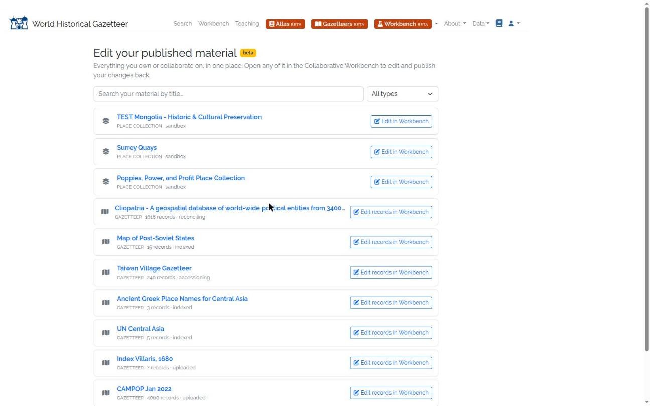
Fig. 1.8 Edit published… — one page listing everything you own or collaborate on (place collections and gazetteers), each with an Edit in Workbench button that checks it out into the right editor.
The Workbench menu also has an Edit published… entry: one page listing everything you own or collaborate on — place collections, gazetteer groups, and gazetteers — with a search box and a type filter. Each collection or group has an Edit in Workbench button that checks it out and opens the right editor; gazetteers link to their page, where you can correct individual records (whole-gazetteer editing arrives later). It’s the quickest way back into anything you’ve published.
1.1.1.4.4. The editor at a glance
Every editor is a single page of numbered steps — a sole-open accordion, so you focus on one at a time. For a Place Collection or Itinerary the steps are:
About — title, description, keywords.
Places (or Stops for an Itinerary) — find and arrange the members.
Map — a preview of the whole assembled collection.
Collaborate & share — save to a team, invite people, get a read-only link.
Save & publish.
A status badge shows whether your work is saved in your browser, saved to your account, or syncing. Nothing reaches WHG until you choose Save to my account or Publish.
1.1.1.4.5. Building a Place Collection
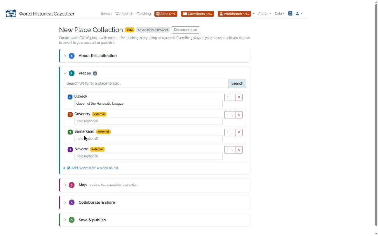
Fig. 1.9 Building a Place Collection — each member resolves to an indexed WHG place, carries an optional note, and can be reordered; places are added by search-as-you-type or extracted from a block of text.
A Place Collection is a curation of places that exist in WHG. Every member resolves to an indexed WHG place — that is what keeps a collection a layer of interpretation (your notes and narrative) over the shared gazetteer, rather than a private fork of it.
Two ways to add places, both in the Places step:
Search as you type. Start typing a place name and matches appear instantly. Once you’ve added a place or two, later suggestions are ranked by nearness to what you already have (a collection’s places tend to cluster), and a small map with numbered pins — matching the numbered result list — shows the candidates so you can pick the right one by location. Candidates that aren’t WHG-indexed are flagged; a Place Collection only accepts indexed places.
Add places from a block of text. Paste a paragraph, upload a file, or import a Google Doc, and WHG’s place-name extractor finds the toponyms and locates them against the gazetteer — you then add the located ones with one click. (This is the one step where text is sent to WHG’s server; the tool says so.)
Each member can carry a note, and you can reorder members with the ↑ ↓ buttons. When you
Publish, the collection is written into WHG’s existing Place Collection model and appears on the
normal public collection pages (/collections/…) with its citation and carousel — nothing about the
public experience changes.
Adding a place WHG doesn’t have yet
If a name has no gazetteer match, the intended path is to contribute it as a gazetteer record first, then add it (via Map your Data → contribute). Building that bridge smoothly is a follow-up; in the current beta, collection members must resolve to an existing WHG place.
1.1.1.4.6. Building an Itinerary
An Itinerary is a Place Collection — same members, same notes — with one difference: order is meaningful. Stops are numbered, you set the sequence with the ↑ ↓ buttons, and the sequence is carried through to the published collection so it can drive an ordered presentation. (A route-line preview and “generate an itinerary from a reconciled Map-your-Data project” are planned refinements.)
What happens to an Itinerary at v4
In v4, an itinerary is no longer a kind of Place Collection. It becomes a PLATO
itinerary: a place in its own right (a SpatialEntity whose
Type names plato:TypeItinerary), with each stop joined to it by a MemberOf attestation that carries
the stop’s sequence and its stay dates. An ordered collection whose stops have no dates becomes a
route instead (Type plato:TypeRoute), with the stops still in
sequence. WHG’s 42 existing ordered place collections will be converted in the same way.
1.1.1.4.7. Building a Gazetteer Group
A Gazetteer Group aggregates published gazetteers (datasets) so they can be browsed and compared together. Search for gazetteers as you type — suggestions are ranked by nearness to those you’ve already added — pick the ones you want, order them, and publish into WHG’s existing Dataset-Collection model and browse pages.
1.1.1.4.8. Editing something already published
The Workbench can also edit items that are already published — not only new drafts. On a published Place Collection or Gazetteer Group, if you have edit rights (you’re its owner, a collaborator, or WHG staff) an Edit in Workbench button appears. It checks the item out: a team-owned working copy is created in your browser and opens in the editor, where you edit it exactly like any draft. When you Publish, your changes are written back into the original — guarded by a check that the published copy hasn’t changed underneath you. If someone else edited it meanwhile, you’re told so and asked to reload the latest rather than overwrite their work. The published record stays the single source of truth; your working copy is explicit and versioned.
1.1.1.4.8.1. Correcting a single record
You don’t have to move a whole gazetteer to fix one thing. On a published place page, if you have edit rights on its gazetteer, a Correct this record button checks out just that one record into a focused editor. It exposes the record’s common Linked Places fields — primary name, country codes, also-known-as names, place types, location/geometry, dates, authority links, and descriptions — each as an add/edit/remove list. You can also re-reconcile the record in place: one click searches WHG and the linked authorities again and lets you attach a fresh match (adopting its location if the record has none). Publish, and the changes are written back to that record alone — its sub-records are rebuilt and, if the record is in WHG search, only that record’s search entry is re-indexed; the rest of the gazetteer is untouched. As with any check-out, it’s guarded against overwriting a change someone else made meanwhile.
Location / geometry is drawn on a map, the same way you draw geometry in Map your Data: pick Point, Line, or Polygon and click the map, and click a shape button again to add another part (making a multi-point, multi-line, or multi-polygon geometry). If the record’s geometry carries date or citation detail, that detail is kept attached when you reshape it. A place whose geometry can’t be edited unambiguously — a mix of geometry types, or several geometries that each carry their own dates or citations — is shown read-only (view-only on the map) so nothing is lost; edit those in the dataset editor. Other fields not yet surfaced (depictions, relations, named periods, and any authority citations) are likewise preserved untouched through a correction.
1.1.1.4.8.2. Suggesting a correction to someone else’s record
You don’t have to own a gazetteer to help fix it. On any published record — its place page, each source box on a portal page, and the detail popup in a gazetteer’s places view — a Suggest a correction button opens the same field editor described above. Make your changes (and, optionally, a short note explaining why), then Submit suggestion. Nothing changes on the record: your suggestion goes to the gazetteer’s owner and WHG staff for review.
Reviewers see pending suggestions in Workbench → Review suggestions: a side-by-side “current → proposed” diff for each, with one-click Accept (applies the change to the record and re-indexes it) or Reject (with an optional note back to you). If the record changed in the meantime, the suggestion is safely set aside rather than overwriting the newer version. A small “corrections proposed” note also appears on the record itself so everyone can see it is under discussion.
This is intentionally scoped to fixing genuine errors — a wrong coordinate, a mis-spelled name, a missing Wikidata link. Recording competing claims from different sources (where two gazetteers legitimately disagree) is a richer idea handled by WHG’s attestation model (see the Data Model); every suggestion is preserved as a provenance record so it can feed that later work.
While in beta, suggesting and reviewing corrections is limited to WHG beta testers and staff.
1.1.1.4.8.3. Correcting records across a gazetteer
Fixing records one page at a time is fine for the odd correction, but when you need to work through many records of a whole gazetteer there is a shell for that. On a gazetteer’s own page (and in the Edit published… hub) an Edit records in Workbench button checks out a set of its records into a list; expand any record to edit every field with the same editor described above, and the ones you change are marked and published together.
Because a large gazetteer can hold far more records than a browser can comfortably hold, check-out is capacity-aware. When you start, the tool measures how much room your browser has and offers:
the whole gazetteer, when it comfortably fits, or
a subset — filter by name and/or country, and cap how many records to pull in — which is the right choice for large gazetteers and for “fix these dozen records” work.
You then edit records locally (saved to your account as you go), and Publish changes writes back only the records you actually changed — each one re-indexed in WHG search, the rest of the gazetteer untouched. Every record is guarded individually: if someone else changed a record since you checked it out, that one is skipped and reported (never silently overwritten) while your other corrections go through. You can re-reconcile any record in place, exactly as in the single-record editor.
While in beta this whole-/subset-gazetteer editing is limited to WHG staff; it opens to gazetteer owners and their team members at the v4.0 release. Very large gazetteers are edited a filtered subset at a time; fully streamed check-out of enormous gazetteers is a later enhancement.
1.1.1.4.9. Collaborating
Every doc-type is a document your team can co-own and co-edit. In the Collaborate & share step you can save the project to a team, invite people by username (as editor or viewer), and create a read-only share link. Where the real-time service is available, team-mates can even co-edit together live. This is the same collaboration substrate as Map your Data — there is nothing extra to learn.
1.1.1.4.10. A note on names
WHG is standardising its vocabulary:
You may have seen |
It is now called |
|---|---|
Dataset |
Gazetteer |
Dataset Collection |
Gazetteer Group |
Place Collection |
Place Collection (unchanged) |
For now this is a display change only — the underlying URLs, downloads, and API are unchanged, so nothing you have linked to or built against breaks. “Place Collection” keeps its name.
1.1.1.4.11. How this relates to the older builders
These doc-types replace the older, multi-step builder forms (the Place Collection Builder and Dataset Collection Builder) with a single local-first editor, while keeping the same outcomes — published collections on the same public pages. The older builders remain available until the new editors reach parity; when they’re retired, their links will redirect into the equivalent New… flow, and this guide will move from the roadmap into Guides & Tutorials alongside the rest.