
1.1.1.3. Map your Data
Coming soon — preview feature
Map your Data is not yet generally available. It is currently in beta behind a beta menu tab, open to WHG staff and invited beta testers, and is documented here in advance so that the design can be reviewed and refined before release. Screens, labels, and behaviour described below may still change. When the feature is released this notice will be removed.
1.1.1.3.1. What it is
Map your Data is a browser-based tool for taking a table of places — a spreadsheet, CSV, TSV, or JSON export — all the way from a messy first draft through to reconciled, standardised data, without uploading anything to WHG first. You import your file, tidy and interpret its columns, match its place names against WHG’s gazetteers, review the matches, and export an augmented copy — all in a single page.
It reaches WHG’s servers for one thing only: to look up candidate matches for your place names. Everything else — your file, your column choices, your review decisions — stays on your own computer.
1.1.1.3.2. Why a new tool
WHG already has a well-established reconciliation and accessioning workflow (see Reconciliation & Accessioning and the Workbench Pathways guide). That flow is built around publishing: you upload a dataset into your WHG workspace, run a server-side reconciliation task, and review the results there. It works well once your data is clean and you intend to contribute it.
Map your Data addresses the stage before that, and some cases that sit outside it:
Local-first and private. Your data never leaves your browser except as anonymous name-lookups. That suits work that is unpublished, sensitive, still in progress, or simply not (yet) destined for WHG at all.
Messy real-world data. Historical sources rarely arrive in tidy WGS84 decimal degrees and ISO dates. The tool recognises a wide range of coordinate formats and historical/calendrical date styles and converts them for you, up front.
Instant feedback. Because it runs in the page, you see the effect of every column choice, filter, and match immediately, with no task queue to wait on.
Small jobs as well as large. It is designed to be pleasant for a single place as much as for a bulk table.
Think of it as a workbench for preparing a gazetteer, complementary to — not a replacement for — the existing publication and accessioning pipeline.
1.1.1.3.3. Getting started
Open the tool from the Map your Data tab in the main menu (marked beta, available to staff and invited beta testers for now). The page is organised as a set of numbered, collapsing panels; you work down them in order, and each one summarises its state in its header once done.
New to it? Take a tour (top of the page) loads the sample dataset and walks you through the whole flow — import, column roles and cleaning, scope, reconciliation, review, map, place types, and export — highlighting each stage as it goes.
Your work is saved automatically in the browser as you go, so you can close the tab and come back to it later. Two controls make this explicit:
Save writes a
.whgprojbackup file — your whole project, including matches and review decisions — to your computer. Restore it later by dropping it back onto the same import area.Clear my data removes the project from the browser entirely.
Note
“Save” produces a local backup file; nothing is sent to or stored on WHG’s
servers. Because the data lives in this browser, on this computer, clearing
your browser storage or switching machines will lose an un-saved project — take a
.whgproj backup for anything you care about.
1.1.1.3.4. 1 · Import a dataset
Drag a file onto the import area, or click to choose one. CSV, TSV, JSON, and
Excel (.xlsx/.xls) files are accepted (including JSON in WHG’s
{id, fields} shape). A .whgproj backup dropped here is recognised and restored
in full rather than treated as new data.
You can also import a shared Google Sheet — paste its link and the tool fetches it as data. (The sheet must be shared so that “anyone with the link can view”.)
To try the tool without your own data, use Load a sample dataset — a small demo that exercises coordinate and date conversion and multi-column (County → Parish → Place) reconciliation.
Once a dataset loads, the panel collapses to a summary and the tool moves you on to confirming the columns.
1.1.1.3.4.1. Extracting place names from text
If you don’t have a table yet — only prose — the tool can build one for you. Under
Extract place names from text you can paste text, use Paste from clipboard,
upload a .txt, .md, .html, .docx, or .pdf file, or load a shared
Google Doc. Files are read in your browser; the tool then finds the place names
and turns them into a table you can reconcile like any other.
This step sends text to WHG
Unlike the rest of Map your Data — which stays in your browser — place-name extraction sends the text to WHG’s server, where a language model detects the names. The text is used only to find place names and is not stored. (Files are read locally; only the extracted text is sent.)
How extraction works, and why the matches are a starting point. Names are first detected by spaCy, a general-purpose language model. Because that model is trained on modern news, it can miss historical, archaic, or non-English place names — so the tool also cross-checks the text against WHG’s own gazetteer, which catches names the model misses and, at the same time, locates them.
When a document mentions several places, the tool uses them together to choose between places that share a name: it finds the geographic region where most of your names have a candidate, and prefers the candidate nearest that region. So Boston alongside Lincoln, Sleaford, and Grantham resolves to Boston in Lincolnshire, while Boston alongside Cambridge, Worcester, and Lowell resolves to Boston, Massachusetts — the same word, read from its company.
The result is a table whose place names arrive already located and provisionally matched to WHG (extra columns carry the matched name, country, and coordinates). Treat these as a well-informed first guess: continue to Reconcile against WHG and Review & confirm to check and confirm them. Very ambiguous names (a Springfield far from the rest of your places) may need a manual choice, and misspelled names won’t be found automatically.
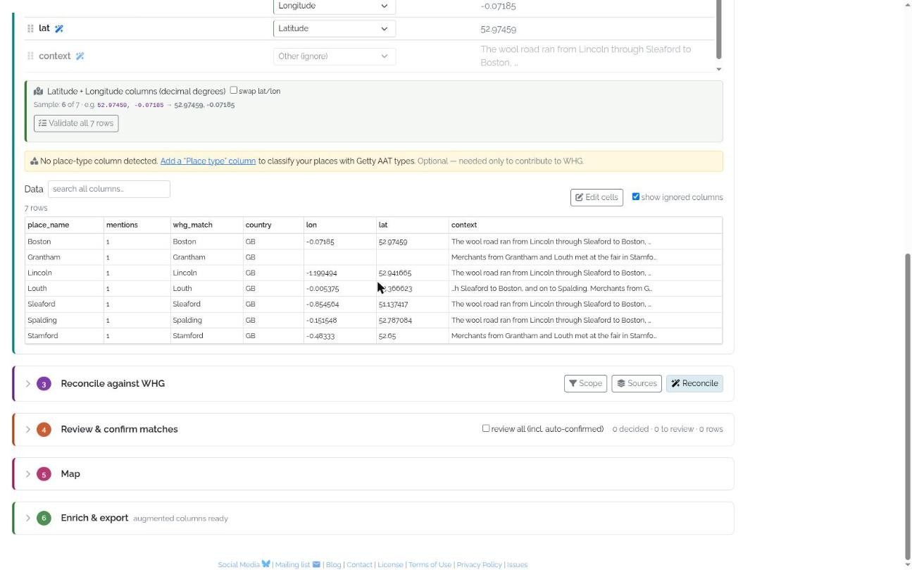
Fig. 1.5 Place names extracted from a passage — Boston, Lincoln, Sleaford, Grantham… — arrive as a table, already located and provisionally matched, ready to move down the numbered steps: reconcile, review, map, and export.
1.1.1.3.5. 2 · Confirm column roles
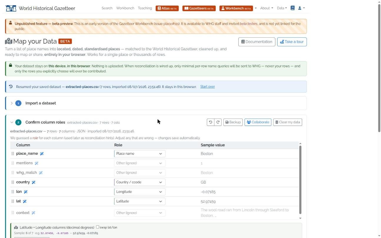
Fig. 1.6 Confirm column roles — the tool guesses a role for each column (place name, country, latitude, longitude…), which you adjust from a dropdown, with a sample value shown for each. A banner confirms the data stays in your browser.
The tool shows a preview of your table and its best guess at what each column is for. You assign each column a role from a dropdown:
Place name — the place name to reconcile (required);
Coordinates / grid ref, or Latitude and Longitude — location;
Date / year — a column of dates to interpret;
Country / ccode — a country hint used to narrow matches;
↳ Contains “…” — marks this column as a spatial container of another column, building the containment hierarchy (see below);
Feature type, Identifier — carried through and used as hints;
Other (ignore) — columns carried through untouched but not processed.
Ignored columns are hidden in the preview by default; a toggle shows or hides them.
1.1.1.3.5.1. Cleaning and reshaping your table
Each column in the roles table carries a small set of controls, so you can tidy the data here rather than going back to a spreadsheet:
a drag handle to re-order columns (ignored columns can be moved too);
a transform button that applies a light cell operation to every value in the column — trim whitespace, change case (upper/lower/title), collapse repeated spaces, or find & replace (plain or regular-expression) — with a live preview of the effect before you commit;
a delete button to drop a column you don’t need.
Every edit — a transform, a reorder, a deletion, a role change — is undoable. Use the Undo / Redo buttons (or Ctrl/⌘+Z and Shift+Ctrl/⌘+Z) to step backwards and forwards through your changes.
1.1.1.3.5.2. Browsing and editing the data
Below the column controls, the Data table shows your whole dataset — not just a sample — and stays responsive even at tens of thousands of rows (only the rows on screen are rendered). Search all columns filters the rows live. Switch on Edit cells to correct values in place: click a cell, edit, press Enter to commit (Esc to cancel). Every edit is undoable, and editing a value in a column you have already reconciled re-flags that row so it can be matched again.
1.1.1.3.5.3. Place types
Contributing to WHG requires each place to carry a Getty AAT place type (a controlled term such as inhabited place, river, or castle) — but this is optional if you only want to export your data. Assign types right here in the table, per row:
if your data has no type column, Add a “Place type” column when prompted;
in Edit cells mode, click a cell in the type column to pick from the AAT hierarchy (searchable, with live suggestions), with a one-click option to apply it to every row sharing that value — so a column of repeated kinds (town, river, church…) takes just a handful of picks.
1.1.1.3.5.4. The spatial hierarchy
If your table has administrative columns (a county, parish, region, province…),
you can tell the tool how they nest, and it will use that nesting to
disambiguate place names during reconciliation. You express the hierarchy directly
in each column’s role dropdown: a container column’s role reads “↳ Contains
‹child column›”. So for a County, Parish, Place table you would have:
County → Contains “Parish”
Parish → Contains “Place”
Place → Place name
From these links the tool derives the containment chain County → Parish →
Place — coarsest first, place name last. There is no separate ordering control:
to re-order or re-nest the hierarchy, just change a column’s “Contains” choice
(for example, point Parish → Contains “County” to swap the two levels), and the
chain updates. The number of levels is unlimited — a
Country → Region → District → Settlement table works the same way.
The tool guesses a sensible default chain on import (recognising common administrative column names and linking them coarse-to-fine down to the place-name column); adjust any that are wrong.
1.1.1.3.5.5. Coordinates
If you assign a coordinate role, the tool detects the format automatically and
converts it to standard WGS84 decimal degrees. It recognises decimal latitude/
longitude (in either order, with a swap toggle when two columns are used),
degrees-minutes-seconds, well-known text (WKT), OS National Grid references
(e.g. SK690965), Irish Grid, and UTM. Where the format is ambiguous you can
override the detected choice. A Validate all rows check reports how many values
convert cleanly and lists any that do not. Insert WGS84 columns adds the
converted latitude and longitude to your table as real columns, so the standardised
coordinates travel with the data through every later step and every export.
1.1.1.3.5.6. Dates
If you assign a date role, the tool parses messy historical dates into ISO start/end values. It handles, among others:
day/month/year in UK order (
dd/mm/yyyy) by default, with automatic detection when a value could only be month-first;month names, ordinals, centuries, and bare years;
BCE/CE (including a leading minus), approximate dates (
c.,circa,?), and open-ended dates (before,after,from…);ranges written in many styles;
English/British regnal years (e.g.
8 Henry VI, and Latin roll clauses);feast days (fixed and movable), and Julian ↔ Gregorian conversion, including Old-Style/New-Style dual dates such as
1641/2;a range of non-Western calendars — Islamic (Hijri), Hebrew, Thai, Śaka, Persian, Coptic, Ethiopian, Japanese nengō, French Republican, and others — converted to Gregorian intervals.
The panel names the calendar or format it detected, and offers the same validate-all check as for coordinates. As with coordinates, Insert ISO date columns writes the parsed start/end dates back into your table as real columns.
Note
Date interpretation is a genuinely hard problem and the parser is deliberately cautious. Always skim the validation report, and treat the converted ISO dates as a strong first pass to be checked, not an infallible authority — especially for regnal years, movable feasts, and calendar conversions near a year boundary.
1.1.1.3.6. 3 · Reconcile against WHG
Reconciliation matches your name column against WHG’s gazetteers using the standard WHG reconciliation service. Only the place name (with a country hint where available) is sent — never your full rows. Progress is shown, and you can stop and resume.
Iterative, containment-chained reconciliation. If you defined a spatial hierarchy, the tool reconciles it one column at a time, parent → child, and gates each step on your review:
You reconcile the outermost column first (e.g. County).
You review and confirm its matches (step 4).
Only then does the next column unlock — and it is matched within the places you just confirmed (a Parish is searched inside its County, a Place inside its Parish). This containment sharpens the disambiguation of same-name places far more than a country hint alone.
A column switcher — parent → child pills, shown in both the reconcile and review panes — tracks each column’s state (ready, in review, confirmed, or locked) and lets you focus a column to review or re-run it. Because a child inherits containment from its confirmed parents, changing a parent decision later resets the columns below it, so the chain always stays consistent.
Note
Containment narrows a child only when the confirmed parent record has an area geometry to test candidates against. Where a parent resolves to a record with only a point — or no geometry at all — that step cannot be reliably constrained. Choosing Sources for an administrative column that favour gazetteers carrying area geometries gives the most reliable containment.
1.1.1.3.6.1. Scope — narrowing the whole dataset
Where per-column Sources choose which gazetteers a column queries, Scope constrains what counts as a candidate across the entire dataset — a coarse filter you set once, before matching. Open Scope (its button shows a badge when any constraint is active) to set any combination of:
Where — a place filter, given as one or more country codes (with type-ahead and validation — start typing a country name or ISO code and pick from the list), a WHG region chosen by name (also type-ahead), or an area you draw on a modal map (a bounding polygon). Candidates outside it are dropped.
What — a Getty AAT place type, chosen with the type picker (see Place types below). Restricts candidates to that type and its descendants — e.g. scoping to inhabited places keeps rivers and buildings out of the running.
When — a year range, and/or a canonical historical period from PeriodO. Search PeriodO by name (type-ahead — e.g. Ming, Viking Age, Hellenistic) or pick from suggestions ranked by your data’s own geographic area and dates; choosing one fills the year range and travels into the exported
when.periods. Candidates whose own dates fall wholly outside the year range are dropped.
Scope is optional, but on a dataset with a clear geographic, temporal, or typological focus it removes whole classes of wrong candidate before scoring even begins.
The What and When settings do double duty: as well as narrowing candidates, a Scope place type or date/period is written into the export and contribution for any row that lacks its own — the quickest way to satisfy the place type and date/period requirements dataset-wide (see the Enrich & export step below).
Controls that shape the results:
Auto-confirm threshold. A match at or above the score you set (or an exact name match) is accepted automatically — unless it is ambiguous: if two or more different places tie for the top score (say a “Devon” in several countries), the row is held back for review rather than guessed. This leaves only the genuinely uncertain cases for you to decide.
Per-column Sources. Each column can draw on its own source gazetteers, which is often what you want: reconcile a County column against a historic-counties gazetteer, a Parish column against a parish gazetteer, and the place names against everything. Open Sources (its label shows which column it targets) and choose all sources, prioritise a chosen few (they sort to the top), or only those few (others are excluded from the query). The list of gazetteers, with record counts, comes from WHG’s registry. A column with no explicit choice uses all sources; a per-column choice never changes another column’s default.
Re-reconcile a column. Realised a column needs a different gazetteer after confirming it? Select it in the switcher, change its Sources, and press Re-reconcile ‹column› to run it again; the columns below it reset so the new containment flows through.
Phonetic matching (on by default).* As well as text matching, the tool computes a phonetic embedding for each name — using WHG’s Symphonym model running entirely in your browser — and sends it with the query, so candidates are ranked by how the name sounds, not just how it is spelled. This helps across spelling variants, transliterations, and scripts. A Language selector (auto-detected from your data, overridable) conditions the embedding; set it if the automatic guess is wrong. The first run downloads the model (~20 MB, then cached); untick the box to fall back to plain text matching.
1.1.1.3.7. 4 · Review & confirm matches
This step walks you through the rows that need a human decision. For each one you see the ranked candidate matches on the left and a map on the right:
candidates are numbered and colour-coded, and the same numbers and colours mark their locations on the map; a ★ shows your own coordinate for the place if you supplied one;
hovering a candidate in the list highlights its marker on the map (and vice versa); accepted candidates get a coloured ring;
hovering a map marker shows the candidate’s source gazetteer (by name) and its alternate names;
the map uses WHG’s portal basemap, with a layer switcher and terrain toggle (your basemap choice is remembered across page loads).
It is built for the keyboard: press 1–9 (or click) to toggle a candidate, x to reject, s to skip, n for no-match, u to undo, and the arrow keys to move between rows. If the first few candidates aren’t enough, load more candidates fetches a larger batch. A “review all” toggle lets you revisit even the auto-confirmed matches. Decisions are saved as you go.
Accepting more than one match. Toggling lets you accept several candidates
for a row — each becomes a closeMatch (a place legitimately linked to more than one
record, e.g. the same place in both GeoNames and a WHG dataset).
Setting the location. A Location toolbar lets you fix the geometry for the row: Use match location copies the selected match’s geometry (point, line, or polygon) into your data, where it stays attributed to the matched record and under that record’s licence (WHG place#240), or you can draw your own — Point, Line, or Polygon, clicking on the map to add vertices and Finish to complete. Press a shape’s button again to add another part (→ Multi-point / -line / -polygon). Clear removes the override. Whatever you set here wins on export.
1.1.1.3.7.1. Filtering the results
On a large table you rarely want to page through every row. A filter panel lets you slice the reconciled results by status (needs review, auto-confirmed, no match), match score, a column’s values, whether a row has coordinates or dates, or a free-text name search. The filter is shared: it drives the results table, the review queue, and the map together, so you can zero in on — say — just the unmatched rows in one county and work only on those.
1.1.1.3.8. 5 · Map
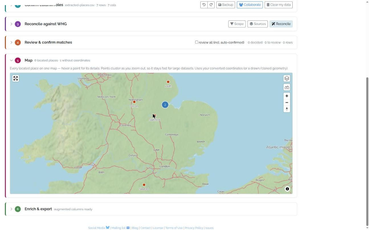
Fig. 1.7 Map — every located row on one clustering map; here the reconciled Lincolnshire places (Boston, Lincoln, Sleaford, Stamford…) plotted from their converted coordinates.
Every located row appears on a single map, built from the coordinates the tool converted (or a geometry you drew or cloned in review). Hover any point to see its details — name, administrative context, date, confirmed match, and coordinates.
The map is designed to stay fast at scale: points cluster as you zoom out (click a cluster to zoom in and split it), and a heatmap takes over at low zoom, so a table of thousands of places renders smoothly in the browser without a server round-trip.
1.1.1.3.9. 6 · That’s a gazetteer — enrich & export
What began as a table of names is now located, dated, standardised, and linked to the world’s places: that is the difference between a spreadsheet and a gazetteer. This final step produces an augmented copy of your table for use elsewhere and — when you’re ready — contributes it to WHG. Everything here is generated in your browser, with nothing uploaded until you choose to contribute.
1.1.1.3.9.1. Augmented columns
Your original columns are always kept; you choose which augmented columns to add:
Confirmed WHG match — the identifier, title, score, and source gazetteer of the candidate you accepted for each place;
Enrich from WHG — richer detail for your confirmed matches (the matched place’s coordinates, variant names, description, and type), fetched from WHG;
Wikipedia link — a
wikipediacolumn holding the article link for each place. Links come only from Wikidata (wd) matches, and only from the place-name column’s match (the lowest level — not higher containment levels such as County or Parish). So a row needs to be reconciled to a Wikidata record (see Sources) to get a link; others leave the column blank. The header is kept unique so it never collides with a column of your own.
(The standardised WGS84 coordinates and ISO dates are added earlier, in step 2, so they are already part of your table.)
Choose a format and export:
CSV and JSON — your table plus the augmented columns, for spreadsheets or other software;
Linked Places (LPF GeoJSON) — WHG’s own upload format, and the best starting point if you go on to contribute the data.
Note
The LPF export maps a sensible subset of your data onto WHG’s upload schema as a starting point — you will usually want to review and complete it (titles, sources, licences, and so on) before uploading.
Validated before you contribute. The Contribute to WHG button builds the Linked Places file and checks it in your browser against WHG’s own upload schema before anything is sent. Until every place passes, the button stays disabled and the Contribution readiness panel lists — in plain language — what is still missing (a place type, a date or period, a location, a name), each with how to fix it; the full technical schema report is tucked behind an expandable Technical validation details line. Problems surface here, rather than as a rejection after upload.
Fill gaps for the whole dataset from Scope. The two most common gaps — a missing place type and missing dates/periods — can be filled once for every place from the Scope picker: set a type under What and a year range or historical period under When. Any row without its own value then takes the Scope value in the export and the contribution.
Contribute to WHG — one click. Once it validates, the button submits the file straight to WHG’s upload and publication workflow for you — no separate export/upload step. You land on WHG’s validation page to review and publish; your local copy stays in the browser. Publishing links your places with records for the same places from other datasets — the step that generates the rich Place Portal pages. The tool is the preparation bench; publication remains the way your work becomes part of WHG.
1.1.1.3.11. Caveats
Warning
Beta — staff & invited testers only. The tool is not yet released to all users; behaviour may change.
Your data is local. It lives in this browser only. Take a
.whgprojbackup before clearing browser data or switching computers, and note that this local copy is not itself a contribution to WHG — publishing still goes through the normal upload and reconciliation/accessioning workflow.Automated conversions need checking. Coordinate and, especially, historical date conversions are best treated as a well-informed first pass. Use the validation reports and spot-check the results.
Reconciliation suggests, you decide. A high match score is a prompt for a human judgement, not a guarantee; the meaning of a confirmed match is a
closeMatchassertion, explained in Reconciliation & Accessioning.